


وصف لـ BackCountry Navigator XE: Outdoor GPS App (New)
Welcome to the next generation of a product for exploring the outdoors on your own terms, using offline topo maps and GPS on your smartphone.
You can also subscribe to the XE List to get notified of status, updates, and deals.
While many of the goals of the new app are the same, we are hoping to achieve a number of goals with the new platform:
Cross-Platform
The original BackCountry Navigator PRO is only available on Android. We will be bringing BackCountry Navigator XE to Android, iOS and the web.
The corresponding app for iOS will be launched through TestFlight
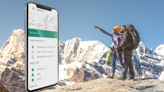
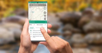
Planning In The Cloud
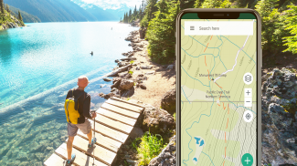
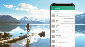
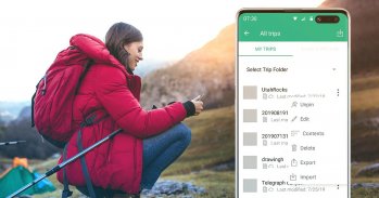
The website bcnavxe.com is the web interface for BackCountry Navigator XE. With it you can plot points, routes, and boundaries for trips, and download them on demand in the mobile app. You can push trips created in the mobile app to the cloud as well for reviewing or sharing.
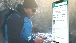
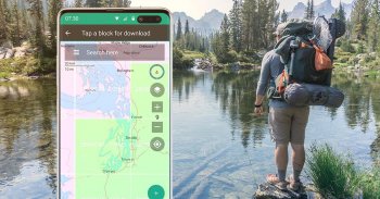
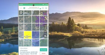
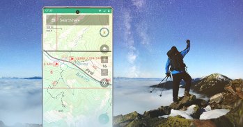
Easy Grid Based Download of Maps
You can try out a simpler approach for downloading and organizing offline maps, choosing large squares at a time. Visualize what you have and what you need.
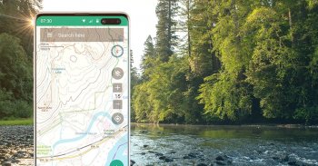
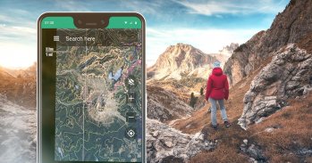
Vector Topo Maps for the World
Vector topo maps for the world hold the promise of crisp multilevel detail, with the ability to download large chunks of the earth's surface in a quick, compact operation. The BackCountry topo map for the world can be viewed in this app and on bcnavxe.com, with an easy process to install them in large blocks.
SALE: 5 and 10 year plans now available for a limited time at bcnavxe.com.
Use coupon SUB2020 to save even more before the end of the month.
If you are looking for an already proven and established product, also consider BackCountry Navigator PRO. Support and development of that app continues on a parallel track.
https://play.google.com/store/apps/details?id=com.crittermap.backcountrynavigator.license
مرحبًا بك في الجيل التالي من المنتج لاستكشاف الأماكن الخارجية وفقًا لشروطك الخاصة ، باستخدام خرائط topo و GPS غير المتصلة على هاتفك الذكي.
يمكنك أيضًا الاشتراك في قائمة XE للحصول على إخطار بالحالة والتحديثات والصفقات.
على الرغم من أن العديد من أهداف التطبيق الجديد هي نفسها ، فإننا نأمل في تحقيق عدد من الأهداف باستخدام النظام الأساسي الجديد:
عبر منصة
يتوفر BackCountry Navigator PRO الأصلي فقط على نظام Android. سنقوم بجلب BackCountry Navigator XE إلى Android و iOS والويب.
سيتم إطلاق التطبيق المقابل لنظام iOS من خلال TestFlight
التخطيط في السحابة
موقع bcnavxe.com هو واجهة الويب لـ BackCountry Navigator XE. مع ذلك ، يمكنك رسم نقاط وطرق وحدود للرحلات وتنزيلها حسب الطلب في تطبيق الهاتف المحمول. يمكنك دفع الرحلات التي تم إنشاؤها في تطبيق الجوال إلى السحابة وكذلك للمراجعة أو المشاركة.
التنزيل السهل المبني على الشبكة للخرائط
يمكنك تجربة طريقة أبسط لتنزيل الخرائط غير المتصلة وتنظيمها ، واختيار مربعات كبيرة في كل مرة. تصور ما لديك وما تحتاجه.
خرائط Vector Topo للعالم
تحمل خرائط توبو المتجهات للعالم وعدًا بتفاصيل واضحة متعددة المستويات ، مع إمكانية تنزيل أجزاء كبيرة من سطح الأرض في عملية سريعة مضغوطة. يمكن عرض خريطة BackCountry topo للعالم في هذا التطبيق وعلى bcnavxe.com ، مع عملية سهلة لتثبيتها في كتل كبيرة.
البيع: خطط 5 و 10 سنوات متاحة الآن لفترة محدودة على bcnavxe.com.
استخدم كوبون SUB2020 لحفظ أكثر قبل نهاية الشهر.
إذا كنت تبحث عن منتج مثبت ومُثبت بالفعل ، ففكر أيضًا في "> BackCountry Navigator PRO. يستمر دعم وتطوير هذا التطبيق على مسار مواز.
https://play.google.com/store/apps/details؟id=com.crittermap.backcountrynavigator.license
BackCountry Navigator XE: Outdoor GPS App (New) - إصدار 2.8.1
(03-09-2023)BackCountry Navigator XE: Outdoor GPS App (New) - معلومات APK
نُسخة APK: 2.8.1الحزمة: com.crittermap.backcountrynavigator.xeتطبيقات من الفئة نفسها
قد يعجبك أيضًا...


